|
Fishing on the Edge of the Outlaw Trail
Mark Tracy
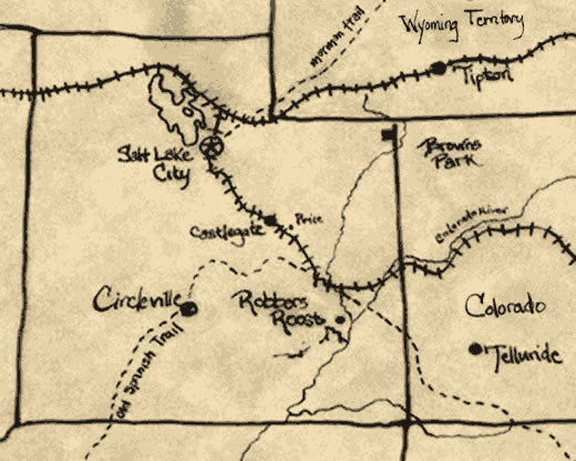
Nineteenth century desperados like Butch Cassidy and his gang, The Wild Bunch, exploited the vast and secluded American West to escape pursuing posies. Their secret hideouts – such places as Robbers Roost, Hole-in-the-Wall, and Brown’s Park – are familiar to many as part of our Western lore. These days, the American West is far more populated and accessible, although a few areas remain largely untouched. One of these is Southern Utah’s expansive high desert and mountain region. This land is much the same as it was in the days when Butch Cassidy (a local boy) and his band of outlaws were sticking-up banks and robbing trains. Southern Utah also boasts one of America’s most notable concentrations of unspoiled, sparsely populated, natural treasures. Were it not for the area’s five, yes five, national parks, the area would hardly see any human presence at all. Yet it is not necessary to venture into the officially designated national parks to get a flavor of the territory. Even outside of the five parks, Southern Utah claims some of the West’s most scenic vistas. Fortunately for me, the solitude and beauty of Southern Utah is a mere half-day drive from my home in frenetic Las Vegas. This has allowed me to visit the region often and, with each visit, I have made new discoveries. Over the years, Southern Utah has served me well as a great escape and as a place to enjoy one of my favorite diversions, fly fishing. As a fly fishing enthusiast, I had become familiar with the small streams surrounding Southern Utah’s Navaho Lake and the little town of Beaver. However, I had heard that further east there were areas of scarcely fished waters with twenty-inch trout. Intrigued, I began to investigate these more remote destinations from maps and literature, and my curiosity grew. I knew I would have to pay a visit. Early September afforded me that opportunity. With ten days of vacation time, I hitched my travel trailer to the Ford F-150 to begin a foray into the wilderness from my jumping-off point of previous ventures: Cedar City, Utah. Driving Highway 14, I climbed a series of steep grades and mountain switchbacks before turning north on Highway 148 toward the town of Panguitch (pan-qwitch) and nearby Panguitch Lake.
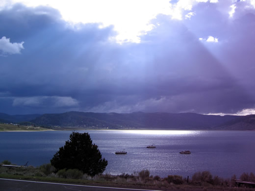
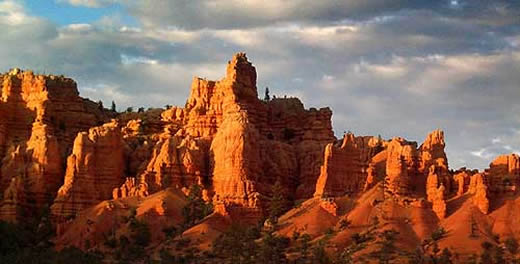
At 8,209 feet above sea level, Panguitch Lake is probably the most popular fishing spot in Southern Utah. Appropriately named by native Paiutes, Panquitch means “big fish” in their language, and I will confirm that there are some big trout in this lake. I will never forget a summer day in 2005 when I trolled a gold Thomas lure and hooked a monster so big and powerful that it quickly unwound every inch of line from my spinning reel. That experience of losing “the big one” was a heartbreaker, but I learned a lesson that day and soon bought a reel with a larger spool. On this trip, however, I decided to concentrate solely on fly fishing, and my destination was not Panguitch Lake but rather the town of Panguitch, eighteen miles further east. The town is situated near two places I intended to fish: the Sevier River, which flows just outside of town, and Mammoth Creek, one of the Sevier’s major tributaries. Arriving in Panguitch late in the afternoon, I parked my travel trailer at the Paradise RV Park just outside of town and made plans to fish the Sevier River the next day. The Sevier is a slow, meandering stream that snakes its way north, draining a large swath of Utah’s southern terrain in the process. Yet the stream never reaches the ocean. Like many of Utah’s other rivers, the Sevier flows into a dry lake where it percolates into the white crusty earth, eventually evaporating into the Great Basin’s desert air. The section of the Sevier I planned to fish lay just south of town, so the next morning I jumped in my truck, got on Highway 89, and headed in that direction. Several minutes later I passed the turnoff to Bryce Canyon National Park. Continuing on, my eyes were drawn to a tranquil scene outside my window where small herds of cattle casually grazed and drank from the river as it slowly wound its way through cottonwood trees of fenced pastureland. As I approached the town of Hatch, population 127, I slowed to the posted speed limit. Two miles beyond the town, Fish Hatchery Road veered off to the right. Directly opposite, on the other side of highway, was an unmarked road – the one I wanted. I took the unmarked road a quarter mile to where it intersects “the old highway,” now just a gravel corridor situated between the Sevier River and present-day Highway 89. I turned right and continued on to where the old highway approaches the Sevier. From here the old highway keeps within fifty yards or so of the Sevier with several access roads leading to the river. However, the first access road I came upon was deeply gouged with tire ruts of caked mud. So I took the next access and drove to a level, grassy area a few feet from the river where I parked my truck. As I made my way down a short path, I paused to watch a white osprey glide past as it scanned the river shallows for its morning meal. I moved to a promising spot where a bend in the river caused gravel to build up and form a foundation at the water’s edge. On the undercut bank on the opposite side of the river, grass draped down like tentacles into the slow moving water. Silt had washed into the river from a thunderstorm the previous day giving the water a light brownish tint. Yet it looked clear enough to fish. I pieced together my fly rod, attached the reel and added a section of 5X tippet to the leader, giving me a length of about 10 feet. As I considered what fly to use, I scanned the water’s surface but did not see much in the way of insects. So I reached into my fly box and pulled out a hare’s ear nymph, my standard go-to fly. I had not touched a fly rod for almost a year but, as I stripped line from the reel and began to lengthen my cast, the rod had a pleasant, familiar feel. Getting into my casting rhythm I imagined the rod to be like a wand whose movement would entice the prey to me. However, after taking several casts with no success I began to wonder. All I had to show for my effort was a couple juvenile fish nibbling at my fly. It was obvious the formula was not quite right. So I switched from small nymphs to big, black woolly-buggers and then to stimulators. But the fish weren’t responding to any of it. Not wanting to quit too early I moved to another stretch of river and then another with no better results. Meanwhile, the sun kept getting hotter and I had a sense that I had gotten up too late. I decided it was time to take a break. I sat down for a drink of water and a snack while pulling out my map. As I scoured the map, my attention was drawn to the Dixie National Forest area and one point in particular, Red Canyon. Noting that the canyon was only a few minutes up the road, I figured that maybe this would be a good time to do some exploring. Getting back on the main highway I went ten miles and turned off on Highway 12. A couple miles later I entered Red Canyon. I had heard that visitors, upon entering Red Canyon, often think they are already in Bryce Canyon National Park. This is easy to understand. Red Canyon, like Bryce Canyon, is a place of striking beauty where wind and water have chiseled into vermilion-colored cliffs a host of different shapes – icons of nature.
I stopped at the visitor center long enough to view its natural history display and some wall maps. I discovered that Red Canyon Campground lay just up the road so I decided to take a look. The campground turned out to be a sort of Eden nestled in the middle of radiant bluffs and Ponderosa Pines. I had just found the perfect place to camp for this leg of my tour. After relocating my trailer to Red Canyon, I took a leisurely stroll around the area. I noticed many campers were speaking German which caused me to speculate as to whether Mormon missionaries had been busy recruiting Germans to Southern Utah. I later asked a ranger at the visitor center about this. She told me Germans in particular were enthralled with the America’s Wild West, some of them even concluding that the best way to take it in was on a rented Harley Davidson exploring all the highways and byways. After hearing this I began to notice quite a few Harleys on the road. I fell asleep easily that night but was awoken early the next morning by the discordant squawk of a jay outside my window. Sunlight was beginning to creep in through the window shade and I could hear the voices and rustlings of nearby campers. As I stretched out my legs, I began to feel suddenly happy and energetic. Deciding to get an early start I got up to brew a cup of coffee and put together a quick breakfast. Today I would fish what I had heard was one of the Sevier River’s most productive tributaries, Mammoth Creek. To get there I headed south on Highway 89, again passing the town Hatch. Except this time I took the exit on the right side toward the fish hatchery. Three miles later I passed the hatchery and continued on for several more miles until I reached the bridge which crosses Mammoth Creek. I parked nearby and grabbed my binoculars to scan the upstream section of the creek as it lazily wound its way through a lush green meadow several miles long. At the top of the meadow, a smattering of rustic summer homes dotted the horizon. From the bridge I also surveyed the creek downstream. There the creek took on a different character. The pace of the water quickened as it skated past gray, fractured rocks with pools and eddies forming in the wake. I eyed the creek as far as I could to where it disappeared behind a cover of forest. I decided to fish this water first. Signs posted nearby said, “Private Property.” However, I had been told the owner was amenable to fisherman asking only that they show respect by not littering the landscape. I decided to do my part, even taking along a plastic bag to store any trash I came across. As I made my way along the river trail, the only sound I was aware of was gravel and twigs crunching beneath my feet. With each step I became more attuned to the solitude of the place. I decided to first walk for a distance downstream and then slowly work my back. After proceeding about a quarter mile, I found a flattened rock on which to rest where I put down my rod and thumbed through my fly box.
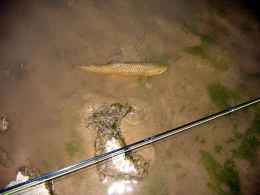
I picked out a size 18 pheasant tail nymph but found it hard to thread the end of the leader through the tiny hook-eye. Meanwhile, a big yellow-jacket that had been following me earlier reappeared buzzing around my head. Annoyed, I swatted at it and felt the perspiration building on my face and collar. But soon I had the hook-eye threaded and I cinched the leader knot tight against it. As I stood up and readied myself, I was greeted by a cool breeze and felt a wave of relaxation come over me. I made an easy cast, cross-current and slightly upstream. I watched my orange fly line bounce along through the shallow riffles, momentarily bending as it slipped over the top of a mossy rock. Behind the rock, the stream dropped off into a dark pool – the kind of pool where brown trout often lurk. Sure enough, I felt a twitch as the strike indicator sunk below the water’s surface. Quickly, I lifted my fly rod to set the hook but I felt no resistance. My first thought was that I had lost the fish. But that was because the fish had created some slack in the line by initially swimming toward me. As I took up the extra slack, I suddenly felt the vibrations of the fish pulsating through my fly rod like an electric current. Moments later the fish made a dash across the pool as the reel’s drag wound out. Gradually I worked the fish back in. For a moment I caught a glimpse of it in the sunlit shallows but then lost sight of it as it made another long, desperate run. Finally worn out, the fish succumbed. I grabbed the leader up close and lifted my catch’s head out of the water. It was a good-sized brown trout about 17 inches long. The hook looked minuscule embedded inside its white lower jaw. Resisting the temptation to keep it, I instead removed the hook and allowed the trout to slide back into the water. Exhausted, it remained motionless in the clear water just a couple feet away from me. I grabbed my camera and snapped a picture before the trout could recover enough to slowly swim off.
Over the next several hours I caught a half dozen more trout, all smaller than the first. I was now into the fourth day of my tour and I decided it was time to move on and explore other fishing waters. The next day I hitched up my trailer and headed east. As I drove out of Red Canyon the landscape suddenly opened wide. For miles in front of me the road lay in a straight incline, ascending into a brilliant blue sky with cotton puff clouds floating in the distance. As I climbed higher the grasslands became interspersed with patches of juniper that soon turned into thick woodlands. I read somewhere that the Great Basin has some of the cleanest air in the country and, as I rolled down the window to breathe in the cool air, I did not doubt it. It was now on to the town of Escalante about an hour away. Escalante sits on the southwest slope of the Aquarius Plateau – a plateau that is sprinkled with an amazing number of alpine lakes, about eighty in all with sixty fishable. The lakes are known for their trophy brook trout but also contain rainbow and cutthroat trout. However, many of the lakes lie at the end of unimproved mountain roads accessible only by high clearance four-wheel drive vehicles or ATVs. Other lakes can only be gotten to by trail. There are outfitters with guides who will take you to these lakes. One such outfitter, appropriately named Escalante Outfitters, is conveniently located on the main highway that runs through town. I decided to pay a visit. It turned out the rate for a full day of guided fly fishing was $225 for one person, $275 for two people, and $300 for three people, which isn’t bad if you can split the cost with other fishing buddies. However, I was by myself. I am also cheap and predisposed to do a lot of exploring on my own. I did avail myself, however, of Escalante Outfitters good coffee and sandwich shop. Fortunately, some lakes are accessible without a guide service, four-wheel drive, or extensive hiking. Two of these are Upper and Lower Barker Lakes. While the road leading to these lakes is unpaved, it is smooth enough to be traveled by ordinary passenger car. The trip took me about forty-five minutes. The Barker Lakes are clear, blue and very picturesque but grassy marshes make shore fishing tough. However, for someone like me – who came prepared with a float tube and could get beyond the weeds – the lakes were a fly fishing paradise. I spent many hours leisurely kicking my way around these lakes, sometimes dragging a nymph behind me and other times casting dry flies to rings on the water left by rising trout. Sometimes I shared the lakes with one or two other anglers; at other times, especially in the afternoon, I was alone. I did not get any trophies but I had a great time catching fish.
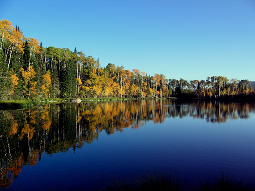
I didn’t want to leave this place but I had just three days left of vacation and had not yet made it to my final fishing destination, the Fremont River. I again packed up and continued east on Highway 12. Fifteen minutes outside of Escalante the highway began to wind through an otherworldly landscape of multicolored minerals and bedrock – part of Grand Staircase National Monument. Further on, the road turned north, traversing several 9,000 foot summits on the eastern crest of the Aquarius Plateau. Along the route I stopped at several overlooks to take in the view of Capital Reef National Park just ten miles to the east. Beyond Capital Reef, another thirty miles on, was Robber’s Roost Canyon – one of Butch Cassidy’s favorite hideouts. It is said that is where Cassidy formed his group of outlaws, The Wild Bunch. However, I would not be going there. I am more of a fisherman than a history buff. Nonetheless, I pondered what the hideout might actually have looked like back in the day. I arrived at the town of Torrey in the afternoon, a town that was established by Mormon settlers in the 1880s. The highway passes through the center of town which is lined with hundred-year-old cottonwood trees whose branches intertwine to form a shaded canopy over the main street. The Fremont flows close to town but I found that much of the river nearby was choked with cattails making it difficult to fish. However, some residents told me of a spot with good access that was not too far away. That evening I drove to a place where the river crosses beneath Highway 12, two miles south of Torrey. I found a parking area on the left and walked across the bridge to where a trail parallels the river. A barbed wire fence – erected to control roaming livestock – blocked the trail. However, in one spot, fishermen had pushed the wire down enough for the fence to be breached. I fished downstream for about two hundred yards to where a small tributary, Fish Creek enters – a point where the brush thickens and the trail peters out. The fishing on this section of river was slow, probably due to recent thunderstorms that had made the river murky. But using a weighed nymph I managed to land a nice 15-inch brown. I planned to fish there again the next day but more thunderstorms quelled that idea. My vacation was coming to an end; it was time to head back to Las Vegas. I left the RV park and headed northwest on Highway 24 toward the interstate. However, I decided I had time for a minor diversion that would take me by the Upper Fremont River and Fish Lake. I had always been curious about these places, but had not put them at the top of my itinerary. Yet they turned out to be among the most scenic spots of the entire trip. Further down the highway, Fish Lake turned out to be a sparkling blue jewel nestled beneath forested slopes. It was mid-September now and the leaves on the nearby aspens shimmered like sequins in the afternoon breeze. Along the ridgeline and across the valley, the foliage was turning bright yellow and gold.
I Found The Forrest Fenn Treasure |